
 Asset Publisher
The State Forests National Forest Holding
 fot. Paweł Fabijański
 fot. Paweł Fabijański
 fot. Paweł Fabijański
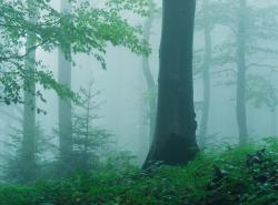
The State Forests National Forest Holding is the largest organisation in the European Union managing forests, which belong to the State Treasury and celebrating its 90 anniversary this year.
Presently, we manage the area of one third of Poland's territory. Not long after the end of the Second World War, there was only 21 % of the area. Every year we plant 500 million of new trees, as we want Polish forests grow all the time.
Every year Polish foresters plant 500 million of trees.
85 % of nature reserves in Poland are located within the State Forests. 40 % of the forests managed by General Directorate of the State Forests are protected within the framework of European network Natura 2000. We fight against many threats: natural disasters, plaques of insects, trees' diseases, fires, pollutions, as well as poaching and vandalism.
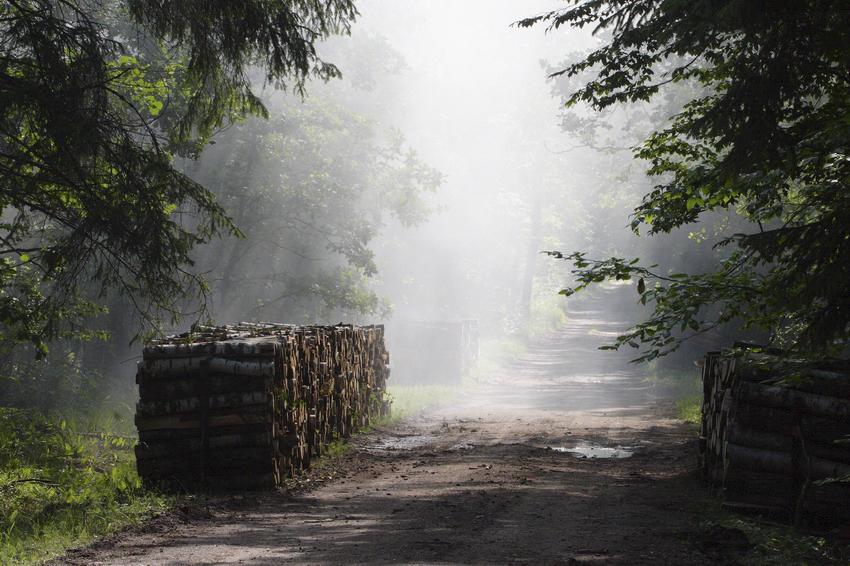
We take care the forestry supplying the market with timber, as ecological and universal material, to be carried on in accordance with rules of balanced development (photography P.Fabjański).
One of our major tasks is making forests accessible to the society. We invite you to take advantage of these beautifully located within the forest wilderness holiday resorts, forester's lodges or guest rooms. That is for you, we create thousand kilometres of hiking trails, cycling paths or camping sites. All the above mentioned, you can find in service www.czaswlas.pl.
We also take care the forestry supplying the market with timber, as ecological and universal material, to be carried on in accordance with rules of balanced development. We obtain over 30 million of cubic meters of wood annually, twice as much as at the beginning of the nineties of the XX century.
Despite of this, the average of wood abundance per hectare of our forests is one fourth bigger than 20 years ago and 40% bigger than the average of European Union currently amounts.
In Poland in sectors connected with the forestry, there work about 375 thousand of people. It means that each 40 working Pole works in the forest.
In Poland in sectors connected with the forestry, there work about 375 thousand of people. It means that each 40 working Pole works in the forest. The sector of wood processing works out approximately 8 % of our GDP (Gross Domestic Product). Among others, thanks to the timber from the State Forests Poland is the 10 largest producer of furniture in the world, and the 4 largest furniture exporter.
The State Forests employ 25 thousand people. That way we are the 9 biggest employer in Poland. Among the largest companies in our country it takes 22 place in respect of its incomes and 11 place in respect of its profits. The value of assets, we manage, reaches 300 million zl. If we add social values, it will be worth one billion zlotych. We do not use money from the budget, but we earn money on our own to support the business. In spite of the financial crisis, since 2002, we continuously note down profits. Moreover, we pay taxes amounting 1,3 billion zl annually.
87 % of Poles think, the foresters are competent. We willingly share our knowledge of Polish forests, of their history and of nature values with the others. We publish books, periodicals, brochures; we also administer the website www.lasy.gov.pl . For children, the youth and teachers, we prepared internet service "E-lynx' Lynx Forest" (www.erys.pl). Our staff has supported schools in field of nature education for years. We also organise many actions to let people broaden their knowledge about forest, nature and ecology.
Asset Publisher


Asset Publisher
Nasze lasy - Nadleśnictwo Kościan
Nasze lasy - Nadleśnictwo Kościan

Siedziba Nadleśnictwa Kościan znajduje się w miejscowości Kurza Góra, przy ulicy Gostyńskiej 89, na skraju lasu, tuż za miastem Kościan, jadąc w kierunku Gostynia.
Zgodnie z Planem urządzenia lasu Nadleśnictwa Kościan na okres 1.01.2014 - 31.12.2023 r. powierzchnia nadleśnictwa wg. stanu na 1.01.2014 r. wynosi 16027,95 ha, w tym 15413,64 ha powierzchni leśnej. Administracyjnie dzieli się na 3 obręby leśne.
• Obręb Kościan - 5855,62 ha
• Obręb Żegrowo - 6437,58 ha
• Obręb Mochy - 3734,75 ha
Obszar terytorialny zasięgu działania Nadleśnictwa to 1075,01 km2. Lesistość Nadleśnictwa łącznie z lasami nie stanowiącymi własności Skarbu Państwa wynosi 16,5%.
Grunty leśne położone są na terenie 11 gmin: Kościan, Krzywiń, Kamieniec, Wielichowo, Śmigiel, Przemęt, Lipno, Wolsztyn, Czempiń, Gostyń, Włoszakowice, oraz 5 powiatów: Kościan, Wolsztyn, Leszno, Gostyń, Grodzisk.
Nadleśnictwo dzieli się na 13 leśnictw:
1. Obręb Kościan - leśnictwa: Bonikowo, Jurkowo, Kotusz, Racot, Turew, Gospodarstwo Szkółkarskie Racot.
2. Obręb Żegrowo - leśnictwa: Błotkowo, Żegrowo, Reńsko, Wyderowo, Ziemin.
3. Obręb Mochy - leśnictwa: Kaszczor, Olejnica.
Gospodarstwo Szkółkarskie Racot o powierzchni produkcyjnej - 6,46 ha, dostarcza materiał sadzeniowy dla całego Nadleśnictwa.
Pod względem regionalizacji przyrodniczo-leśnej nadleśnictwo znajduje się w Krainie Wielkopolsko – Pomorskiej (III), Mezoregionie Równiny Opalenicko-Wrzesińskiej (III.24) północna część obrębów Żegrowo i Kościan, Mezoregionie Kanałów Obry (III.28) północno-zachodnia część N-ctwa, Mezoregionie Wysoczyzny Leszczyńskiej (III.31) pozostała część N-ctwa.
Zestawienie powierzchni leśnej nadleśnictwa wg. pełnionych funkcji zgodnie z Planem urządzenia lasu Nadleśnictwa Kościan na okres 1.01.2014 - 31.12.2023 r. przedstawia się wg stanu na dzień 1.01.2014r. następująco:
powierzchnia lasów stanowiących rezerwaty przyrody - 37,28 ha
powierzchnia lasów uznanych za ochronne - 10315,93 ha
powierzchnia pozostałych lasów (lasów gospodarczych) - 5060,43 ha
Udział typów siedliskowych lasu nadleśnictwa zgodnie z Planem urządzenia lasu Nadleśnictwa Kościan na okres 1.01.2014 - 31.12.2023 r. wg stanu na dzień 1.01.2014 r. przedstawia się następująco:
Bs 1,34 ha -
Bśw 2059,14 ha 13,7 %
Bw 0 ha -
Bb 0 ha -
BMśw 3927,72 ha 19,5 %
BMw 139,28 ha 0,9 %
BMb 1,84 ha -
LMśw 4074,36 ha 27,1 %
LMw 993,30 ha 6,6 %
Lśw 2234,75 ha 14,9 %
Lw 1202,18 ha 8,0 %
Ol 282,34 ha 1,9 %
OlJ 1106,41 ha 7,4 %